

Things are getting hectic in the western Pacific. A "triplet" of tropical cyclones is straddling the equator, a part of the ocean where storms have no business being. One of them, Tropical Cyclone Maila, is already surprising meteorologists by its proximity to Earth's central waistband. Together with the other two, the trio appears to be setting the stage for an extremely rare super El Niño that could define global weather and climate records for this year and next.
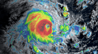
The rest of this article is behind a paywall. Please sign in or subscribe to access the full content.Over the past week, Tropical Cyclone Maila has been cooking up a storm over the warm waters of the Solomon Sea, part of the Pacific between Papua New Guinea and the Solomon Islands. This is curiously close to the equator. In fact, it’s one of the strongest storms on record to be this close to the equator.
Why don't tropical cyclones go near the equator?
It’s unusual because tropical cyclones rarely form within 300 kilometers (about 186 miles) of the equator, and they certainly never cross it. While Maila is still well outside this threshold, it is pushing boundaries. According to the Weather Network, a strong cyclone has not been seen in this part of the Solomon Sea since records began back in 1951.
This is because the Coriolis effect – the force created by Earth's rotation that causes large air masses to spin – is essentially zero at the equator. Without this swirling effect, patches of stormy weather are not able to organize and "spin up" into a full-blown cyclone.
Crucially, the Coriolis effect acts in opposite directions depending on which side of the equator they're on: counterclockwise in the Northern Hemisphere and clockwise in the Southern. This effect means the equator serves as an invisible wall for storms that do manage to form nearby. Theoretically, a hurricane or cyclone crossing it would need to stop rotating entirely, reverse direction, and start spinning the other way to survive. In reality, this never happens.

A triplet of tropical cyclones too
But that’s not all that’s going on in this pocket of the ocean. A triplet of tropical cyclones is brewing in the Pacific on both sides of the equator, two south of the “line” (Maila and Vaianu) and one to the north (Invest 90W). Twin cyclones can occur two to three times a year in the Pacific Ocean. The equator will effectively slice through the same storm system, creating two “twins” on either side that act in tandem with one another.
“Imagine putting your finger into a pool and moving it in a straight line. You would see swirls develop on either side of your finger,” climate scientists Tom Di Liberto explains in a NOAA blog post about twin cyclones. “The same concept is at play with tropical cyclones, it is just Mother Nature doing the stirring.”
However, it is most unusual to get a triplet of cyclones at the same time.
Some forecasters have suggested the trio of cyclones is another good indication that a potent super El Niño is likely to emerge this year. The cluster of storms is expected to generate a westerly wind burst that shoves warm water eastward across the Pacific, a key ingredient needed to kickstart El Niño, which is defined by warmer temperatures in the eastern Pacific. A comparable pattern unfolded in 1997 and 2015, when twin cyclones formed early in the season, AccuWeather senior meteorologist Chad Merrill told Newsweek.
If a powerful El Niño does strike this year, it will be very bad news for climate records in 2026 and 2027. However, it’s still relatively early to forecast such things, so let’s cross that bridge if and when we get to it. Gulp.